e have here some 14 trips that you may like to
take when you stay with us. Each trip requires use of a car and they
should take a day to complete as they are written. You don't have to stick
to the routes of course, and you can to stop off at as many places of
interest as often as you like for a more relaxed timetable. e have here some 14 trips that you may like to
take when you stay with us. Each trip requires use of a car and they
should take a day to complete as they are written. You don't have to stick
to the routes of course, and you can to stop off at as many places of
interest as often as you like for a more relaxed timetable.
The
Ordnance Survey Landranger 1:50,000 Maps for each trip are given with each
trip, but you will be able to use any standard road map.
We have here 7 day trips for you. Another 7 days out can
be found by using the link at the bottom of the page.
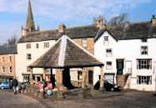
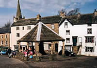 Day 1. Alston Moor. Day 1. Alston Moor.
Take a slow stroll around Alston taking
time to look at the quaint back streets, and local walks, the gallery and
the Narrow gauge railway. Drive up to Nenthead on the A689 and call in at
the North Pennines Heritage Trust at Nenthead Mines. From Nenthead drive
over the hill and down into Garrigill, a charming, picturesque village
with a traditional village green. You can follow the Pennine Way from
Alston to Garrigill for a relaxed stroll with a welcoming bar at each end
of the walk.
Alternatively you can hire a bicycle for the day or longer
and enjoy a longer journey. Please let us know via the booking form if you
wish to hire a bike as 4 weeks notice is required to guarantee availability.
ORDNANCE SURVEY MAP: Landranger 1:50,000
SHEET 86 or 87.
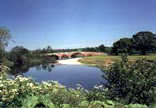
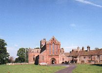
 Day 2. Eden Valley. Day 2. Eden Valley.
Take the A686 towards Penrith
going over Hartside Pass. Drive through Melmerby and to Langwathby. When
you reach the village turn off the road into the centre. You will find
Eden Ostrich World here a very popular visitor attraction in the Eden
valley. Follow the road through the town to Little Salkeld (visit the mill
and perhaps walk along to Lacy's Caves) and then visit Long Meg and her
daughters, the third largest stone circle in Britain (follow the signs).
After Long Meg turn left and head off to Glassonby and then up to
Kirkoswald. From Kirkoswald head off to Armathwaite. From Armathwaite keep
the river Eden on your left and head to Lazonby. From there go through
Great Salkeld and then on to rejoin the A686. You can drive on to Penrith,
Brougham Castle, Mayburgh Henge and Askham village if you have time, or go
further to Appleby on the A66. Then home to Alston.
ORDNANCE SURVEY MAP: Landranger 1:50,000
SHEETS 86,90 & 91.
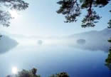
 Day 3. Eastern lakes. Day 3. Eastern lakes.
Drive to Glenridding at the
southern end of Ullswater (probably the best of the lakes), stopping at
Aira Force (a National Trust attraction, Aira Force is a waterfall above
the lake) on the way if you wish. Follow the signs on the left to the
public car park which is by the Jetty for the Ullswater Ferry. You can
take the ferry back up the lake all the way to Pooley Bridge and back.
From the car park follow the shoreline to the right of the car park, on
foot to the Booth for boat hire. You can hire either a rowing boat or
motorboat from here by the half hour. If you have taken one of our packed
lunches with you hire a boat and row over to the far shore. You will find
a small inlet with a beach there where you can relax and have your lunch
and enjoy the views. Alternatively you may like to go to the island or eat
in the boat.
Options: 1. Drive back to Pooley Bridge and take the
road through the town (B5320) turn right along the road and head for
Askham, follow the road to Bampton/Bampton Grange and then travel on to
Haweswater. You can drive the entire length of the reservoir and there is
a car park at the end of the road.
Option 2. Jump back in your car and
turn left when you leave the car park and head off towards Patterdale,
carry on up Kirkstone Pass. You can either keep on the main road and drive
down to Windermere and Bowness-on-Windermere, or turn off to the right and
head for Ambleside ( this is a narrow and at times very steep road, so be
prepared).
ORDNANCE SURVEY MAP: Landranger 1:50,000 SHEET
90.
 Day 4. The Romans and Hadrian's Wall. Day 4. The Romans and Hadrian's Wall.
From the hotel car
park go right and over the bridge, then turn right onto the A689 and carry
on towards Brampton. You will come to a junction with the A69 at the end
of the road. Take the road opposite into Brampton. You can take a look
around the town centre if you wish (the church has some impressive stained
glass windows by Burn Jones).Otherwise, turn right at the junction and
then left following the signs for Lanercost Priory. It is worth stopping
at the priory for a look around. Keep right in Lanercost village and go up
the hill, and bearing right follow the signs for the wall. You should now
be on a straight road following the line of the wall. Further up the road
you can stop at Birdoswald (Camboglanna).Carry on to the junction with the
B6318 and turn right, keep on this road through Greenhead. There are a
great many places of interest along the road such as mile castles, forts
and camps built by the Romans. Housesteads and Chesters are popular places
to stop and look at Roman remains. Vindolanda is off the main road, just
follow the signs and then rejoin the B6138 after your visit. Keep on the
B6318 (right) at the roundabout at Chollerford and go over the bridge.
Follow the road along the wall until you get to a roundabout and take the
A68 down Stagshaw Bank on the right. Go under the A69 and into Corbridge
for a look around. Double back and take the road on your left that leads
to a Roman Fort. Carry on this lovely country lane all the way into Hexham
turning left at the junction and going over the bridge into the town.
Follow the signs for Allendale and Alston (B6305) toward the top of the
town. A few miles out of Hexham after a long straight you will come to a
corner in the road by a farmhouse where there is a turn off to the right.
Take this road and then at the end of the road turn left onto the A686 and
drive on to Alston.
ORDNANCE SURVEY MAP: Landranger 1:50,000 SHEETS 86 &
87.
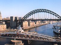 Day 5. Newcastle (not on Saturdays). Day 5. Newcastle (not on Saturdays).
Take the A686 to Haydon
Bridge to the A69 and turn right at the junction. Drive all the way to the
roundabout over the A1. Here you can go straight on and into Newcastle
town centre or turn right onto the A1 and visit Gateshead Metro Centre.
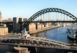
Newcastle city centre has a great many attractions in the form of shopping
(including the largest Marks & Spencers in the country), eating, great
architecture, and the famous quayside with the spectacular bridges.
Recently added to with a magnificent footbridge.
Gateshead Metro
Centre is the largest indoor shopping mall in Europe. Household names such
as House of Fraser, Waterstones, Boots, HMV, etc. The Metro Centre is
almost a complete town in itself. There is a large selection of eateries
and a multi screen cinema and a children's fun park. Outside the main
centre but within its boundaries are a large IKEA and a branch of ToysrUs.
To get back to Alston follow the signs for the west, A69 and or Hexham
and reverse the instructions above.
ORDNANCE SURVEY MAP: Landranger 1:50,000 SHEETS 87 &
88.
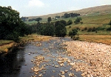
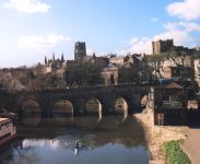 Day 6. Durham and more. Day 6. Durham and more.
Drive up the hill through Alston
and turn left at the Police station onto the A689. Keep on this road
through Nenthead and climb up into the fells and over the border into
County Durham. Down into the valley you will see the Killhope Lead Mining
Centre. This is a worthwhile place to visit with a recreation of a lead
mine and a Large Water Wheel. Carrying on the A689 all the way through
Stanhope, Crook, Willington and Brandon into Durham. Durham city centre is
a lovely old layout with a maze of lanes with some great views of the
Cathedral and castle at the top of the hill which the city surrounds. Good
shopping. There is a multi storey car park conveniently in the centre of
the town. After a look around Durham take the A167 south until you reach
the junction with the A688. Go right through Spennymoor and into Bishop
Aukland for a stroll around. From there head off to Barnard Castle again
on the A688. Another town worth investigation with impressive ruins of the
castle from which the town takes its name. Leaving Barnard Castle, keep
the castle on your right and go over the bridge onto the B6277. Cary on to
Middleton-in-Teesdale (over the bridge), turn left at the junction ad
keeping on the B6277 drive on up the valley past Newbiggin to Alston. You
will pass High Force waterfall on your way which you may like to have a
look at. It is popular with visitors and has a large car park.
ORDNANCE SURVEY MAP: Landranger 1:50,000 SHEETS 86 &
92.
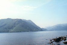
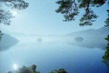 Day 7. Northern Lakes. Day 7. Northern Lakes.
Take the A689 to Brampton and turn
left on to the A69 to Carlisle. Exploring the town if you wish. Through
the town past the castle find the A595 and follow all the way down to
Bothel. Turn left onto the A591 and follow the road towards Keswick
passing Bassenthwaite lake on your right. When you reach the junction with
the A66 turn right and go to Cockermouth. After a look around the town
head south on the A5086. Passing Pardshaw carry on until a turn off to
your left to Mockerkin and Loweswater. Go through Loweswater and then turn
right onto the B5289 in Lorton Vale. Heading south east you will pass
Crummock Water and Buttermere on your right. Travel on up and over
Honister Pass and down to Seatoller and Rossthwaite. Drive on to Keswick
passing Derwent Water. Keswick is worth looking around and you can walk
down to the lake and take a ferry trip around. Great views of famous fells
such as Cat Bells and Skiddaw. From Keswick drive east on the A66 to
Penrith then follow the A686 into the North Pennines to Alston.
ORDNANCE SURVEY MAP: Landranger 1:50,000 SHEETS 85, 86
& 89.

|